The Avon Dam to Shipley Bridge
It could also have been called River Avon More to See, and I had even considered The Littlest Avon.

This is the start of my long advertised and long awaited journey along the length of the River Avon in South Devon. There are other river Avons in Britain, quite a few of them, because the name Avon is the old Brythonic word for river and many rivers named back then kept the word Avon while losing their real name as new invaders arrived and assumed the local name for the river was Avon. In modern Welsh the word for river is still Afon, the single f being pronounced as the English v, there being no v in the Welsh alphabet.
Brythonic was an ancient Celtic language of the British Isles spoken between the Iron Age and the fifth century, by a race of people called Britons. Therefore the words River Avon, actually mean River River, which is a tautology, the merging of two words that mean the same thing, taken from two different languages
Some background........
England's shortest River Avon is just seven miles long, and this is it. The river rises near Ryder's Hill, famous for its standing stones and triangulation survey station, on the boggy moorlands of the three hundred and sixty eight square mile, Dartmoor National Park, in the county of Devon and flows in a southerly direction towards the south Devon coastal town of Bigbury - on - Sea. The river flows through the Devon villages of South Brent, Avonwick and Aveton Gifford and also forms part of the Avon Dam Reservoir, situated near South Brent, which was built in 1957.

In this series of posts we will visit all of those villages and their history as well as seeing how they fare today. I intend to explore anything of interest along the route, so although there will be photos of running water and bridges aplenty, there will also be the unexpected in a no holds barred exploration of life along the Avon.

This was as high up as I got. I had intended to get to Ryder's Hill, the top of the watershed, from where all water heads this way to the sea, but it is a long trek across boggy moorland and often clouded in mist, as you can see. In any case it is there on the horizon on the right and if I ever get there on a clear day I will add a link here.

The first thing to notice is the water level, which as you can see is lower than normal, as it has been a record breaking drought summer. A heatwave and drought that broke, the day we went to the Dam.
The other thing to say here is that in this first post I am placing the photos in reverse order as we had to walk a few miles to get here, yes I do walk, just not across boggy moorland. This whole series will feature photos appearing in the same order as the river runs, irrespective of when they were taken. The builders of this dam conveniently built a very nice tarmac road all the way here and kindly allow anyone to walk along it. So visually walking backwards, let's get started.

These sheep live here and were not at all impressed by my efforts, panting as I was at the end with the steep rubble strewn slopes up the side of the dam. It was difficult to know if the water coursing down my face at this point was perspiration or rain, probably a mixture of both.

Next to the flooded part of the dam on the northern bank, there are remains of ancient settlements, some now submerged, so we know that there has been human activity along this river for thousands of years.
This monument includes three enclosed prehistoric settlements and a medieval farmstead situated on a gentle south facing slope of Dean Moor overlooking the Avon Reservoir. The southern settlement, survives partly within the Avon Reservoir, as an irregular shaped enclosure containing at least 15 stone hut circles, a length of walling and two animal pens. A further four structures attached to the outer western face represent further huts and pens. Excavations were carried out within this enclosure by Lady Fox in 1954-76. In the huts her findings included post-holes, hearths, internal divisions, paved floors and an underground storage chamber. Artefacts recovered included pot-boilers, whetstones, pottery, unfired clay, flint tools, saddle querns, spindle whorls and two cornelian beads. Of significant interest was the discovery of a deposit of iron ore and a small piece of tin slag. This last find provides the only conclusive evidence of Bronze Age tin exploitation on Dartmoor.
Aileen Mary Fox, Lady Fox, FSA was an English archaeologist, who specialised in the archaeology of south-west England. She notably excavated the Roman legionary fortress in Exeter, Devon, after the Second World War. From the late 1940s, she undertook key excavations in south-west England, shedding new light on prehistoric occupation of Dartmoor, Iron Age hillforts in the region, and the Roman military presence in Cornwall.
She had a comfortable middle class upbringing, her grandfather being the first Manager of The Hong Kong and Shanghai Bank. In her autobiography she said that her teenage observation of the idleness and triviality of the leisured Edwardian woman's life bred in her a determination to do something more challenging. webarchive.org

The Avon Dam is quite an impressive structure and probably more so after a winter of rain when there would be a cascade down those central steps, the spillway. The dam was constructed in 1957 to provide water to the South Hams and the reservoir itself covers around 50 acres. A new dam on the Avon river was proposed in 1948 and approved by the government in 1950. Construction started in 1954 on the concrete gravity wall which rises to the spillway, 94ft above the river level, and now holds 305 million gallons. (A bit less than that on this particular day).
As you can see, the rain was by now lashing down viciously, desperate to refill the dam. Weather like this is a major problem with the outside. In fact it was quite challenging even getting these shots, which you will notice were taken on my phone, being Android Galaxy shaped. The reason they are phone shots is that I had been here before on a beautiful sunny day before the drought broke and hadn't made it as far as the dam and on this day I went unexpectedly so didn't have my camera.

The reason I never quite made it on the better day was the remoteness added to the parking app and the fact I took so many photos on the route up that I did not judge correctly how far it was. So I found myself not at the dam with not enough time to get there and back to my car before my parking ticket expired.
The parking app story is a classic. The car park has a machine which only takes cash although you can pay by app, although there is no signal available which means you can only pay by cash. I didn't have any coins and neither did anyone else, so do I risk getting a big fine? I decide to start back down the mountain to try and get some signal, stopping and checking my phone whenever the landscape opened up slightly. After backtracking about a mile I have some signal, but it is single track with nowhere to pull over. This road is deserted so I stop right in the middle and go for it, I get as far as the pay button when the app decides my bank needs to confirm who I am, I mean who else would be up here on a mountain trying to pay £2.00 to park on some rubble? Are the bank so worried a thief might have hacked my phone to steal £2.00 to park?
This road that has only seen my car for 3 hours (twice) now decides to bring another car along driven by an idiot, because I squeeze my car into the hedge to let them past and they won't go, they just sit there. This means I am now forced to drive further, in fact another mile. Now I can back into a gateway and let the idiot go past. No signal. I have to drive again, you have to give me full marks for determination.
Now I have signal again so I start back at the beginning. It turns out that the app is linking to a cancelled card that I no longer have. So now I have to enter a whole new set of card details and try again. The bank still wants to check it is me, as if any petty criminal would be this desperate for £2.00. Now I am screaming inside.
Eventually I manage to turn the car around, no mean feet, and drive more than two miles back to the car park. Such is my devotion to completing this exercise before it had even got off the ground. All of which just goes to explain why shortly, these photos are going to change from misery and wet to sunny and gorgeous.
This is the first bridge over the Avon. I am not promising every one of them because I have since tried to find one and never made it due to a road closure and flooding so we'll see, this project is still ongoing.

It was also a day of animals in various shapes and sizes and another IT warning I will share at the end. We've already seen the sheep, so here is a cow, a Highland cow to be exact. It was milling around in the shrubbery wondering why these two legged fools keep appearing even in terrible weather like this.

Terrible but beautiful.

This is the second bridge over the Avon, still a long way from the main road, so both bridges so far are just for dam access.

This is your first opportunity to see what a beautiful river it is. Up here the landscape is quite steep so the fall of water is quite rapid and picturesque. Lower down the route, the river slows and widens as it approaches the sea.

This was a real surprise, because it appears that most of the dam must be either automated or remote controlled, so we had seen nobody water related until now. This side road leads to the water treatment plant and I can only surmise that this truck is full of delicious chemicals about to be added to our drinking water to counteract all the sheep pee that must end up in the reservoir. Admit it, it had crossed your mind. In any case when this road was built back in the fifties, trucks were about a third of this size, so he was having a fun time not just trying to get around the bend but also just to get up the steep slope. He's got another half a mile to go.
In the foreground is The Hunters Stone. On it are inscribed the names of Masters of the Dartmoor Foxhounds celebrated in the history of Brent Moor House and various later hunts.
J. Ll. W. Page notes that the stone existed although not naming it when he wrote; “Between it and Shipley Bridge, we shall have our attention drawn to a large rectangular boulder by the roadside – for we have reached a road now – and upon approaching, observe that it is inscribed. But not to any British chief, ‘Romanized’ or otherwise, but to certain west-country worthies, whose names the eccentricity of a former owner of Brent Moor House has caused to be on the rock.”

About half way along this route there are remains of buildings that once stood alongside the river.

Now this was a surprise, we do not often see wild roaming pigs, especially in old ruins.

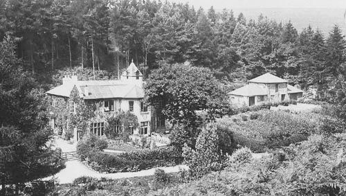
These are the ruins of Brentmoor House. Brentmoor House had originally been a small 17th-century farmstead. In 1855, Francis Meynell returned from his naval career and purchased the house and estate. Meynell had joined the navy in 1836 and spent a year in home waters before sailing to the Far East. From 1837-39, he was aboard the Alligator, around Australia, and was then deployed as a midshipman to the Calliope as part of the China War between 1840-43. He also spent two years off the west African coast, between 1844-1845, aboard the Penelope which was conducting anti-slavery operations. He also produced a number of paintings of the slavery he encountered in his naval career as part of his own campaign against the abhorrent trade.

Meynell was a noted artist who painted a number of watercolours and his illustrated journal is held by the National Maritime Museum in Greenwich. The estate at the time of Meynell's purchase was said to extend to around 3,000 acres.
Garden Reach, Calcutta, HMS Calliope saluting, 1841, by Francis Meynell R.N.

After much tragedy in his family at this house, during which time both his children died of illness, he eventually retired alone to Dawlish on the coast. Brentmoor was then left empty for a number of years (in the 1881 census it was listed as 'uninhabited') but in the 1880s or 1890s, the house was owned by Mr. C.A. Mohun-Harris who bears responsibility for the carved inscriptions on the Hunter's Stone..

During WWII, from 1941-44, the house was leased by the Friends Relief Service (FRS) as an evacuation home for 16 deaf children from Hartley House school in Plymouth, plus three teachers and five staff from the FRS. After the war, the house became part of the Youth Hostel Association network until 1955 when population growth and urban expansion many miles away now created a new challenge for the house in the valley, the building of the dam.
The FRS was an official arm of the Religious Society of Friends (Quakers),set up during the second world war to relieve civilian distress:first from bombing and evacuation in Britain and then in the wake of fighting in Europe and farther afield. In 1947 the Nobel Peace Prize was awarded to the Religious Society of Friends (Quakers) worldwide for its relief work during and after both world wars.
Part of the citation reads:
“It is the silent help from the nameless to the nameless which is the Quakers’ contribution to the promotion of brotherhood among nations.”

Given the dam is two miles away from Brent Moor House, it may seem far-fetched to blame it for the demise of the house. However, given that the house was being used as a youth hostel, if there had been a catastrophic failure of the dam wall, the water would have thundered at immense speed down the valley and destroyed the house quicker than any alarm could warn the inhabitants. The house was closed up and dereliction and vandalism took their toll before the Royal Marines were brought in to finish the task with explosives in 1968, leaving the skeletal, moss-covered ruins we see today. Lostheritage.org.uk


There now follow some simple river pictures. The landscape has opened up at this point.

This has to be the most perfect picnic spot.


The water has the dark tan colour one associates with water from peat covered highlands in Britain.


Then the river narrows again, where some flood debris has collected. This gives some indication of how much power the river has when in flood.

This is a natural boulder of granite, around which a mature oak tree has wrapped itself. Judging by the size of the tree, this sight almost certainly predates the building of the dam.

Back at the car park and the puzzling sight of what I liken to Inca ruins. These ruins and the earthworks on the slopes above are the remains of two of Dartmoor's past industries. In the mid 19th century this was the site of a naptha distillery, where inflammable oil was distilled from peat, extracted from the moor. The naptha industry was short lived and the site was then adapted for clay refining.
Clay was moved here in channels in liquid suspension and where my car is now parked were large settling and drying pits where the particles settled out and the clay was dried and cut into blocks. It was last produced here in 1932.


Right next to the car park, and now steep sided and narrow again, it's the perfect spot for a bridge. Bridge number three, Shipley Bridge. It is Grade 2 listed by English Heritage.
English Heritage describe it as a road bridge over the River Avon, at this point a moorland brook. Probably C18, widened in C19. Granite rubble. single span round arch with dressed granite recessed arch ring. Parapets with large roughly squared granite coping stones. This bridge was originally a narrow packhorse bridge and widened in C19 on the north upstream side. It was described by the Rev Samuel Rowe as a "single arched moorstone bridge" but according to James Coreen, the County Surveyor, it was "a very rough bridge thrown across from two rocks".
It is highly likely that with Bronze Age settlements nearby that there could well have been a bridge on this spot for a long time, at least hundreds possibly thousands of years. Some of the rough stone bridges on Dartmoor, as described above are almost impossible to date.

Now my IT warning. Take great care using SatNav in these parts. On the way to the dam our SatNav took us down a lane which got progressively narrower and narrower and where tarmac gave way to stone cobbles. This wasn't tarmac long lost, this was cobbles that had never seen tarmac. This is the original road surface, how all roads in England looked at one time.

This was our first opportunity to turn around after the road ahead on the rolling SatNav map abruptly came to an end.

Our arrival created quite a stir amongst the locals who hadn't seen a car in years, but we were very grateful that this gateway was here, giving just enough room for a many pointed about turn.

Part two features the river from Didsworthy Bridge to South Brent Church.

I was telling my wife about your G road classification yesterday after we found one courtesy of our sat nav. Fortunately this 'short cut' that we headed down with some trepidation caused no dramas but reading this post a little out of order made me smile.
Love that river! My kind of place. I would have a hard time leaving such tranquility and beauty - thanks for the tour!
That would have been terrible to have had to go back in reverse :) I was thinking the same thing about the red paint on the sheep as well Gethin? Great history lesson and photos!!
Why?? Why?? Why??? Do these things happen to you? You seem to always run into obstacles. I am starting to really wonder about you.
I find the highland cows the cutest cows ever. Dennise took a few pics of them when she was in Scotland last month which made me wish I had taken. I love their bangs.
Btw what is an android galaxy shape also why are the sheep marked with a huge red dot....target practice?