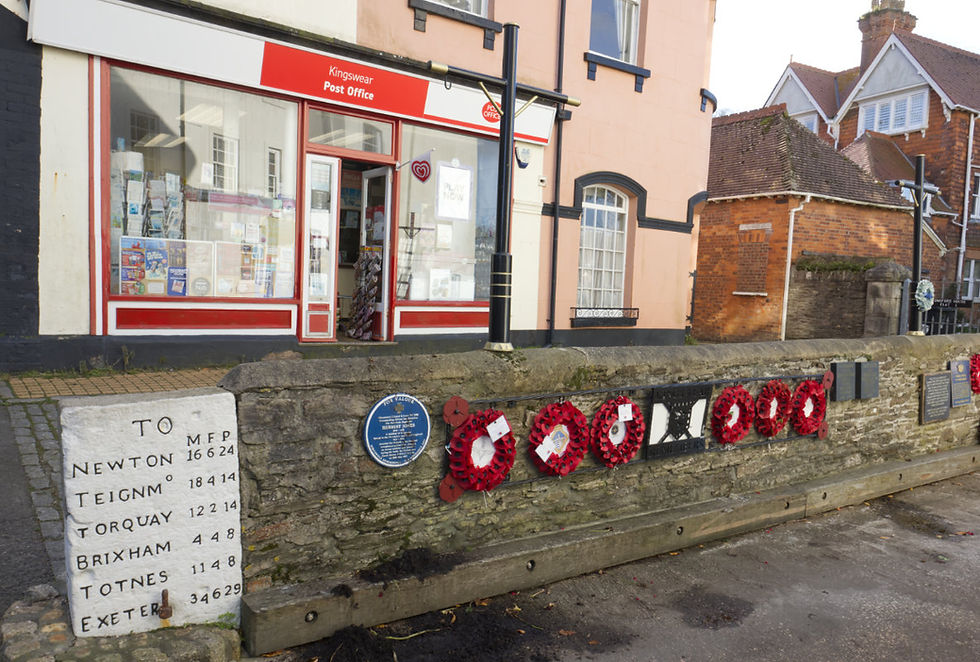
That's a perch in case you were wondering, which you probably weren't. I have mentioned this milestone in Kingswear before but it cropped up again today.
Crop up is a strange saying to crop up actually, and it's only just occurred to me that it has no obvious derivation. If something unexpected happens, why do we say it cropped up, it makes no sense.
I am now digressing from perches by the way, in case you were wondering at my wandering. It seems the original meaning was mainly geological, and described mounds of rock that protruded from the ground, as in an outcrop of limestone or even coal. Outcrops cropped up. At some point in the early 1800's it seems to have shifted into the figurative use we have today. From a mound of coal cropping up from down below, to a fleeting thought cropping up as you do a photo walk, it is a sort of mental mound appearing in your brain.
Getting back to the matter at hand or even the feet at hand, sixteen and a half of them to be exact, as they make up a perch. The perch is that P in the right hand column on the milestone below. In a sense, this milestone is also an outcrop of rock.

The M is for mile and the F is for furlong. This sign cropped up today because I went to Brixham to do a photo walk, and all of those photos will appear at a later date. That photo walk was all about feet too, feet walking up steps, lots of them. It was all about walking back down those steps too.
While in Brixham I found this old stone without feet or perches. It is another outcrop of rock. It just marks the end of the road, literally. It was slightly confusing given it says the end of the Dartmouth and Torquay Turnpike, and I was not in Dartmouth or Torquay. I am assuming that this was a branch off the Torquay to Dartmouth road that ended right here, almost on the very spot where Prince William of Orange stepped foot on to another stone, on the 5th November 1688, thereby claiming his right to be King of England. More about that stone in a later post.

Turnpike stone. About 1838. Short, round-headed piece of Devonian limestone, its west face incised with the inscription END OF THE DARTMOUTH & TORQUAY TURNPIKE. The stone appears to be in roughly its original position;
I digress again, this time about William of Orange. The real point of this post, however, was how it dawned on me that we were in fact so much more accurate in our measurements in the past than we are today, or at least on our signs giving us those measurements.
I had gone to Brixham on the ferry from Dartmouth to Kingswear, and as I left the town centre in Brixham there was a sign pointing back to Kingswear and it stated it was four miles distant. I carried on driving out of town on that road for half a mile when I came to another sign, saying Kingswear four and a half miles. How can this be? .......and which one was correct? Even I know that four minus a half does not make four and a half.
After an indeterminate number of miles I got to the ferry slipway in Kingswear and here I saw the distance I am going to rely on as being correct. Why? Because someone carved this measurement in a large "outcrop" of granite, and it took a lot of effort and skill. I particularly like the tiny letter O at the end of TEIGNM signifying the abbreviation of Teignmouth. That was my extra bit of joy today, the icing on my cake. Along with the fresh scallops I bought in Brixham for my supper. I was wandering past the fish market and the scallops just cropped up, but I digress again.
The true distance was in fact 4 miles, 4 furlongs, and 8 perches. Using my solar powered Texas Instruments calculator that has been serving me well for over twenty years, as long as I am not in a subdued light, I make that 4.525 miles. I am consequently now sitting under what Peter Kay would call "The Big Light", that bright one that you don't normally use unless you are trying to work out the distance to Brixham on an antique Texas instruments solar powered calculator.
There weren't any perches on the calculator, by the way, not when it hails from Texas. The perches I had to Google, even though Google is in California. I like to think that there is a small back office at Google, not the huge world domination office out front, but a little one near the back door, next to the janitor's cupboard, where a lonely young man pores over yellowing documents that explain what a perch is, so that he can digitise that information for us. What a hero!
What does all of this mean? This means that the stonemason was being very precise, which makes me all the more inclined to think this is the accurate distance. Of course Google maps thinks it is 4.8 miles, what do they know, in California?

Milepost situated on slipway of the Lower Dart Ferry. Circa early C19. Rectangular granite post.
Disclaimer - Please note, I am not a historian, a mathematician, a geologist, or an etymologist, or an entomologist for that matter. Do not quote me as I often use unreliable sources. Always do your own research.

Kommentare